Projects
Cobb Creek
Overview
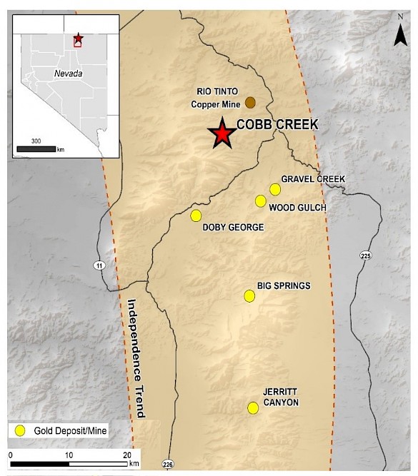
 Cobb Creek hosts a National Instrument 43-101 compliant, historical resource of 174,000 ounces of gold, named the McCall gold deposit1. The project occurs at the northern end of the Independence Trend, one of the most important gold belts in northern Nevada. The Independence Trend hosts the Jerritt Canyon district, three other Carlin-style gold deposits, and the recently discovered epithermal gold deposit known as Gravel Creek.
Cobb Creek is comprised of 318 unpatented mining claims and is located close to Highway 225 in Elko County Nevada. The relatively new Western Exploration discovery, Gravel Creek, occurs only 12km southeast of Cobb Creek and is reported to “contain an in-place unclassified mineral inventory of 1.4 million ounces of gold and 21 million ounces of silver”. (Muntean, Davis, and Ayling, 2017)2.
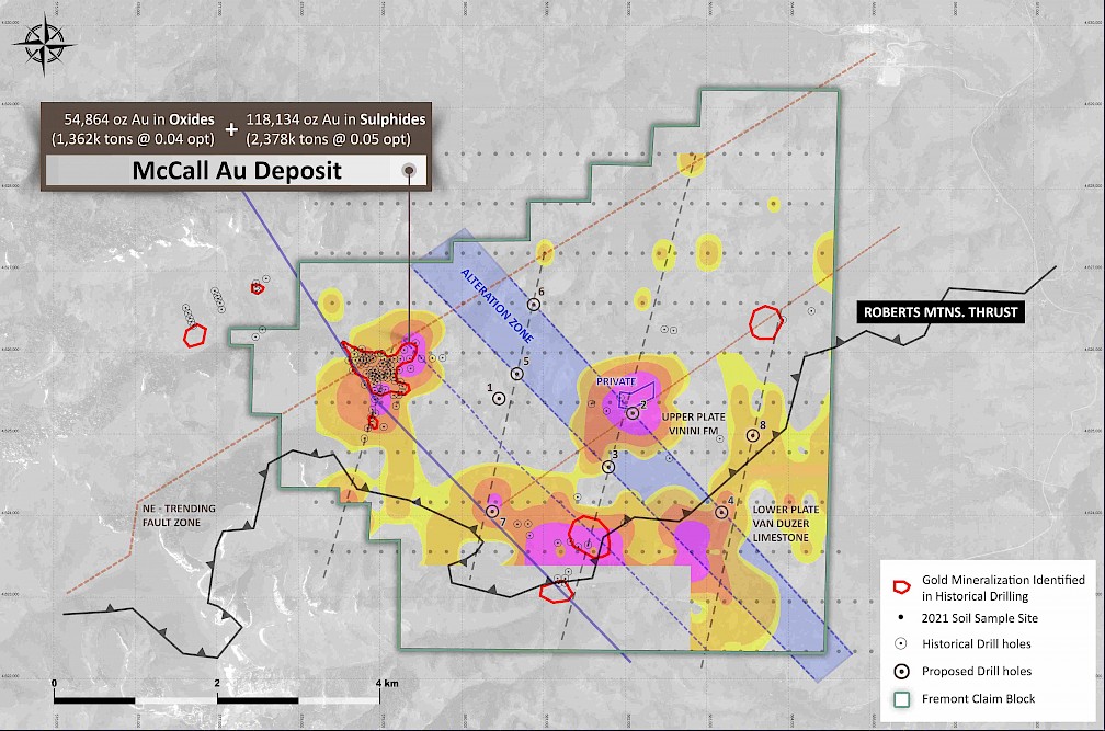
A recent geochemical soil survey reveals a number of important new gold and pathfinder element anomalies that lie three to five kilometers southeast and east of the McCall gold deposit and is discussed in the geochemical section below.
Historic Exploration at Cobb
Cobb Creek was last drilled in 1992. Most of the historical drilling (over 140 drill holes) was shallow. One of the best drill results was cut in hole COBRC-84, which returned 33.5 metres of 1.92 g/t gold from 18..3 meters depth, including 12.2 metres of 4.09 g/t gold. See the table below for more drill results.
|
Hole ID |
From m |
To m |
Intercept m |
Gold g/t |
|
|
COBRC-3 |
13.7 |
29.0 |
15.3 |
2.86 |
|
|
COBRC-20 |
7.6 |
16.8 |
9.2 |
2.32 |
|
|
COBRC-23 |
22.9 |
36.6 |
13.7 |
1.78 |
which includes 6.1 m @ 2.59 g/t Au |
|
COBRC-24 |
3.1 |
10.7 |
7.6 |
2.60 |
|
|
COBRC-26A |
48.8 |
56.4 |
7.6 |
1.90 |
|
|
COBRC-40 |
53.4 |
62.5 |
9.1 |
3.25 |
|
|
COBRC-73 |
13.7 |
19.8 |
6.1 |
3.13 |
|
|
COBRC-86 |
19.8 |
24.4 |
4.6 |
3.17 |
|
|
COBDDH01 |
24.4 |
38.1 |
13.7 |
2.07 |
|
|
COBDDH03 |
29.0 |
36.6 |
7.6 |
2.97 |
|
|
COBRC-84 |
18.3 |
51.8 |
33.5 |
1.92 |
which includes 12.2 m @ 4.09 g/t Au |
|
COBRC-85 |
21.3 |
25.9 |
4.6 |
3.66 |
|
|
COBRC-105 |
42.7 |
54.9 |
12.2 |
1.85 |
Historical mineral resource estimate
The McCall deposit contains a historical mineral resource estimate which is set out in the table below.
|
Resource |
Mineralized |
Cut-Off |
Grade |
Ounces |
|
|
Classification |
Zone |
(opt) |
Tons |
(opt) |
Gold |
|
Indicated |
Oxide |
0.01 |
1,362,233 |
0.04 |
54,864 |
|
Indicated |
Sulphide |
0.01 |
2,378,000 |
0.05 |
118,134 |
The historical mineral resource estimate (“Historical Estimate”) was performed by and reported in a technical report prepared by Michael R. Pawlowski for Stacatto Gold Resources Ltd. and dated October 30, 2004. The Historical Estimate is based on a total of 72 drill holes with continuous zones of gold assays above 0.01 opt gold that could be reasonably interpreted to be continuous in three dimensions based on the construction of nine cross sections, 200 feet apart. The methodology employed in the Historical Estimate is detailed in the 2004 technical report by Pawlowski1. A qualified person has not done sufficient work to classify the Historical Estimate as a current mineral resource or mineral reserve and Fremont is not treating the Historical Estimate as a current mineral resource or mineral reserve.
Cobb Creek Geology
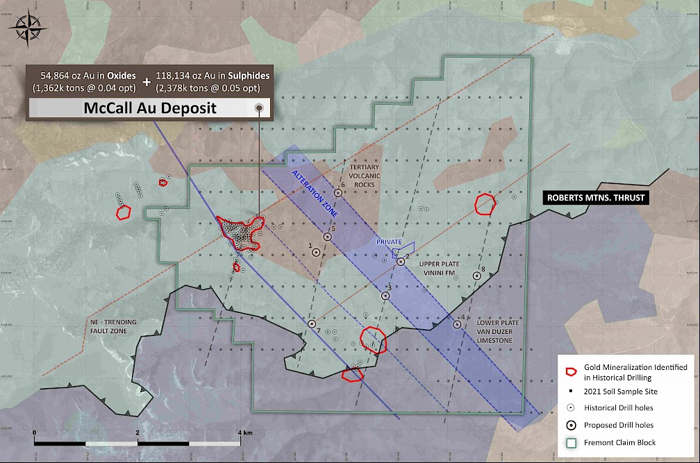
 The figure above shows the geology of the project area, with mapped and inferred northwest-trending fault zones in blue with strong alteration and known gold mineralization commonly at the intersection of northeast-trending and north-northeast-trending fault zones. The faint points are the sample site locations of Fremont's 2021 geochemical survey. Mineralized zones from historical drilling are shown outlined in red in the following figures. There is ample evidence of near-surface epithermal alteration, similar to Gravel Creek 12 km to the southeast, and also potential for deeper Carlin-type mineralization along and beneath the Roberts Mountains thrust in lower-plate carbonate rocks which are strongly altered in the southern part of the claim block.
Although McCall has been described as a pre-Tertiary orogenic vein system, there is evidence suggesting the presence of a Tertiary mineralization system, according to V.P. Exploration of Fremont, Dr. Clay Newton. “There are extensive exposures of quartz-veined and brecciated jasperoid, which are strongly anomalous in gold and pathfinder elements. Additionally, the close proximity of outcropping silicified lower plate limestones supports the theory that a Carlin-type gold target exists at a relatively shallow depth __ a target that has never been drill tested.
Gold Soil Geochemistry and drill targets
 The figure above shows gold results from Fremont’s recent geochemical soil survey which displays a strong gold-in-soil anomaly directly above the McCall gold deposit and reveals a number of important new gold-in-soil and pathfinder element anomalies three to five kilometers southeast and east of the McCall gold. These anomalies have never been tested by previous drilling.
1 Pawlowski, M.R., 2004, Technical report on the Cobb Creek Property, McCall Area, Elko County, Nevada
2 Muntean, J.L., Davis, D.A., and Ayling, B., 2017, The Nevada Mineral Industry 2015, Special Publication MI-2015, Nevada Bureau of Mines and Geology.


